Descent: 10 feet (3 m)
Description:
This profile starts at Entrance Way (just above Kings Mountain)
and heads west. For the hill enthusiast, it
has a nice section of 18%. For the connoisseur, there are several
short climbs on the sideroads off Patrol Road. One in particular,
Patrol Court, starts with a left switchback that hits 23% on the
outside, and 28% on the inside.
Altimeter altitude
(Altitude linearly interpolated from altimeter
samples, and smoothed with a 0.04mi gaussian.)
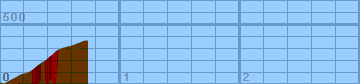
Each horizontal line is 100 feet. Each vertical
line is 0.2 miles. Gradiometer grade
(Grade linearly interpolated from gradiometer
samples, and smoothed with a 0.04mi gaussian.)
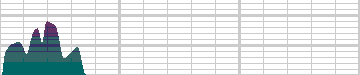
Each horizontal line is 2% grade. Each vertical
line is 0.2 miles. Altimeter grade
(Grade linearly interpolated from altimeter
samples, and smoothed with a 0.20mi gaussian.)
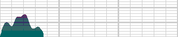
Each horizontal line is 2% grade. Each vertical
line is 0.2 miles. Comparison of grades
(Green grade is from the gradiometer, magenta grade
is from the altimeter, and white is where they
overlap.)
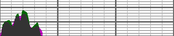
Each horizontal line is 2% grade. Each vertical
line is 0.2 miles.
Overall (averaging my first 20 hills),
the gradiometer grade averages 0.63 (% grade)
higher than the altimeter grade, with a standard
deviation of 4.5 (% grade per road).
This error may be due to:
-
Uneven sampling -- I take more samples when the
hill gets steep.
-
Calibration error (of the gradiometer or
altimeter).
In the end, though, I think that each individual
sample is accurate to within about 2% for that
instantaneous segment of road. My results may
not always agree with my altimeter, but they are
generally repeatable within 1%. I think that
I just need to take more samples to generate
more accurate graphs.
Raw Data:
Dist    Grade   Alti.   Location
----    -----   ------  --------
0.00    -6%      570    Entrance Way
0.03     7%      560    635
0.08    10%      590    entering left turn
0.14    11%      620    660
0.17    11%      640    Patrol Court
0.22     6%      650
0.26    13%      670
0.28    15%      690
0.32    16%      720
0.35     8%      740    steep section looms ahead
0.37    18%      750    725
0.39    18%      770
0.44    17%      810    780
0.47    16%      840
0.52     5%      860    Roan Pl.
0.60     8%      880    850
0.65    10%      900
0.70     0%      920
0.73     0%      920    dead end
Back to
Lucas's
cycling gradiometer page.